Erin has strengthened into a Category 4 hurricane as of Saturday. It’s the first hurricane of the 2025 Atlantic season, which officially formed mid-Friday morning. Some Tropical Storm watches remain in effect for parts of the northern Leeward Islands, according to forecasters at the National Hurricane Center.
Erin formed in the eastern Atlantic Ocean on Monday and is rapidly intensifying. The NHC said rough surf conditions from the storm could impact states like Florida on the U.S. East Coast, as well as the Bahamas and Bermuda, early next week.
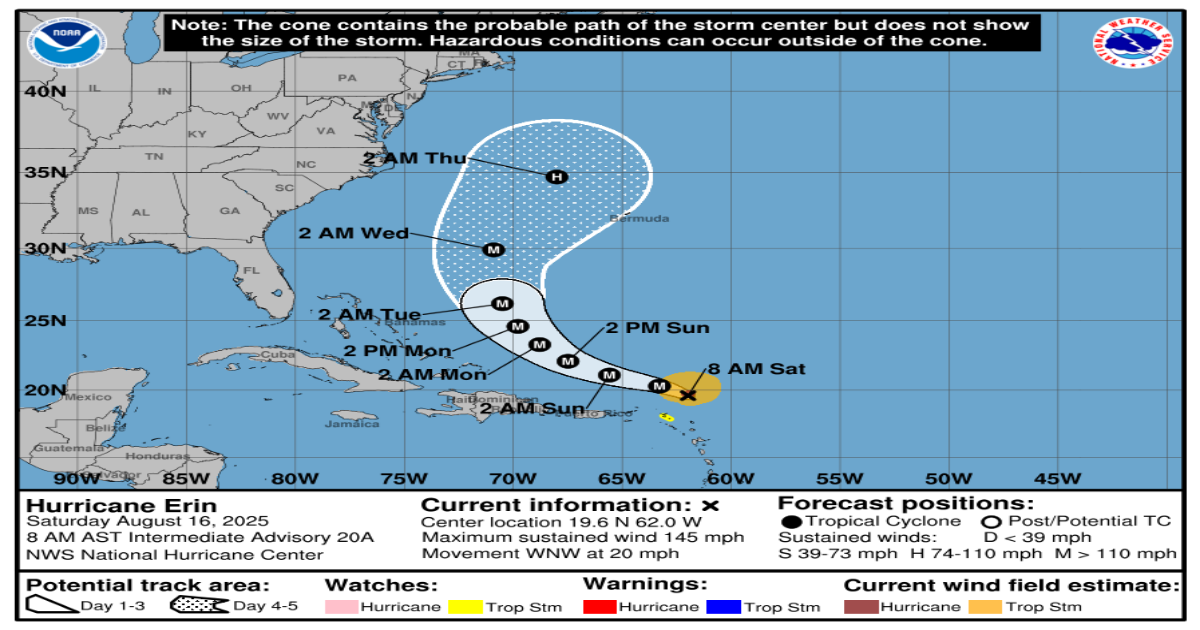
Where is Hurricane Erin, and what is its path?
As of 8 a.m. ET Saturday:
- Erin was located 120 miles northeast of Anguilla.
- The storm has maximum sustained winds of 145 mph.
- It is moving west-northwest at 20 mph.
The storm is expected to continue to move west-northwest through the weekend, gradually decreasing in speed. Early next week, the storm is expected to turn toward the north.
Starting today into Sunday, the outer bands of Erin are expected to bring areas of heavy rainfall across the northern Leeward Islands, the Virgin Islands, and Puerto Rico. Rainfall totals could range from 2 to 4 inches, with up to 6 inches in isolated areas, which could lead to flash or urban flooding and cause mudslides and landslides, the hurricane center said Saturday.
“Swells generated by Erin will affect portions of the northern Leeward Islands, the Virgin Islands, Puerto Rico, Hispaniola, and the Turks and Caicos Islands through the weekend, the NHC said. “These swells will spread to the Bahamas, Bermuda, and the east coast of the United States early next week. These rough ocean conditions will likely cause life-threatening surf and rip currents.”
What are the chances it will intensify?
Erin reached Category 4 strength on Saturday.
“Continued rapid strengthening is expected today, followed by fluctuations in intensity through the weekend,” forecasters said.
A tropical storm becomes a hurricane when maximum sustained winds reach at least 74 mph. Hurricanes are rated on the Saffir-Simpson Hurricane Wind Scale, ranging from Category 1 to Category 5, with 5 being the most severe. A storm is considered a major hurricane when it reaches Category 3 strength, with sustained winds of at least 111 mph, according to the NHC.
Watches and warnings in place
As of 8 a.m. ET Saturday, these are the following advisories in place, according to the NHC:
Tropical storm watches are in effect for:
- St. Martin and St. Barthelemy
Forecasters added that, “A Tropical Storm Watch means that tropical storm conditions are possible within the watch area, in this case within the next 12 hours.”
The NHC advised that the northern Leeward Islands, Virgin Islands, Puerto Rico, Turks and Caicos and the southeastern Bahamas should continue to monitor forecasts of Erin.
How is hurricane season shaping up?
The 2025 Atlantic hurricane season, which began June 1 and runs through the end of November, has a 50% chance of being above normal.
Last week, forecasters at the National Oceanic and Atmospheric Administration slightly updated the number of expected storms to 13-18 (estimated at 13-19 in May), five of which could become major hurricanes (with winds of more than 111 mph).
A typical hurricane season averages 14 named storms. We’re currently about halfway through this year’s hurricane season, and as of Friday, Aug. 15, there have been six so far: tropical storms Andrea, Barry, Chantal, Dexter, and now Hurricane Erin.