PHOENIX (AZFamily) — The monsoon made an unlikely appearance in the Phoenix area on Wednesday night, causing power outages and palm tree fires, but it avoided the East Valley for the most part.
A storm system developed in the Deer Valley area and then moved southwest, hitting central Phoenix, Tolleson and the Avondale areas.
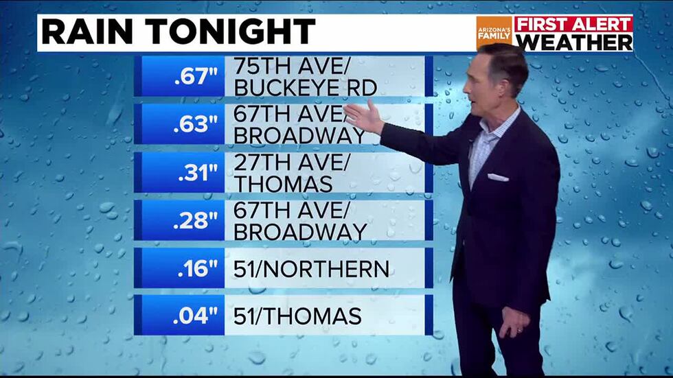
Rainfall totals
A severe thunderstorm warning was issued for a significant portion of the West Valley that expired at 10 p.m.
Isolated storms popped up in northern Phoenix and moved through the Valley, heading toward the Avondale area on Wednesday night.
Arizona’s Family was at the scene near Seventh Avenue and Indian School Road in central Phoenix, where rain began falling after 9 p.m. Shortly after, the traffic lights went out at the busy intersection.
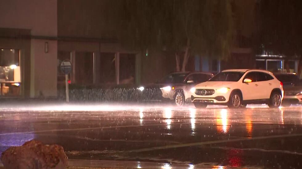
Rain was seen at 7th Avenue and McDowell Road.(Arizona’s Family)
In addition, a palm tree fire sparked by lightning caused roof damage to an adjacent home.
Phoenix firefighters say this happened near 3rd Avenue and Encanto Boulevard.
According to Arizona Public Service (APS), about 3,300 customers are without power in central and uptown Phoenix. About another 2,000 Salt River Project (SRP) customers are without service, as of 9:45 p.m.
Storm chances then ramp up further into Thursday, with improved chances for measurable rain across the Valley being on Friday, which is a First Alert Weather Day.
The biggest potential impacts will be strong winds, patchy blowing dust and pockets of heavy rain. This could also be the first time we see measurable rain at Sky Harbor since the beginning of July.
A blowing dust advisory also is in effect until 11 p.m. south of the Valley, affecting areas such as Tucson, Casa Grande, and Maricopa, with blowing dust and poor visibility possible along highways and roadways. A flood advisory is also in effect for parts of the West Valley through 12:45 a.m.
We will watch for any outflow boundaries from showers and storms outside of the Valley to kick up the dust across the Valley this evening, especially to the southeast.
The extreme heat warnings that have been in effect since last week will finally let up this evening.
High temperatures are still above the normal of 105 for this time of the year, closer to 110, but we will start to see temps come down over the next few days. We’re looking at highs in Phoenix around 103 degrees on Friday and Saturday, before they warm back up to near 110 by the middle of next week.
As far as any sign of the monsoon, increasing moisture across the state will bring in better shower and thunderstorm chances for the next couple of days. Showers and thunderstorms are already firing off across the High Country and eastern Arizona higher terrain.
By the weekend, drier air will filter into the state as a trough pushes that moisture out to the east. Temps will then be around 108-110 Monday through the middle of the week.
See a spelling or grammatical error in our story? Please click here to report it.
Do you have a photo or video of a breaking news story? Send it to us here with a brief description.
Copyright 2025 KTVK/KPHO. All rights reserved.
